KASHMKIR NEWS
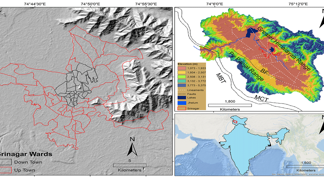
SRINAGAR: Jammu and Kashmir has been placed entirely into the newly created Zone VI — the most severe earthquake risk category — under India’s revamped seismic map, marking a major shift in how the region’s earthquake vulnerability is assessed.
The Bureau of Indian Standards (BIS) introduced the new map in its 2025 Earthquake Design Code, assigning the entire Himalayan arc, including Ladakh, to the highest hazard level. The updated system is grounded in modern probabilistic seismic hazard assessment methods, which take into account detailed fault data, rupture potential, shaking intensity and subsurface geological conditions. This scientific approach replaces older methodologies that leaned heavily on historical earthquake frequency and past structural damage.
According to BIS, the revised framework more accurately estimates peak ground accelerations likely in future quakes, ensuring safety regulations align with the latest understanding of seismic dynamics rather than outdated assumptions.
Specialists say the change corrects earlier inconsistencies that split the Himalayas across Zones IV and V, despite shared tectonic risks. Dr. Vineet Gahalaut, director of the Wadia Institute of Himalayan Geology, noted that the new map finally acknowledges the danger stemming from fault segments that have remained locked and building stress for decades. Many of these zones have not produced major ruptures in nearly 200 years, leading past assessments to undervalue their destructive potential.
The updated construction code requires structures in J&K to withstand severe pulse-like motions typical of earthquakes near active faults. New guidelines tighten standards on displacement, structural flexibility and energy absorption to avoid large-scale collapse. Additionally, non-structural elements like parapets, suspended ceilings, electrical lines, water tanks and façade components must be securely anchored — as such components often injure people even when buildings remain standing.
Provisions also call for heightened attention to liquefaction, soil behaviour and site-specific geological response, making thorough ground studies mandatory for new development in susceptible areas. Critical facilities including hospitals, schools and major public infrastructure must be built to remain operational immediately after a major quake.
The 2025 map further introduces an “exposure window,” combining hazard levels with population density and infrastructure footprint. This is particularly relevant for rapidly urbanizing districts such as Srinagar, Jammu, Baramulla and Anantnag, where even moderate tremors could cause heavy disruption.
While the Himalayan belt faces sweeping reclassification, southern India — considered tectonically stable — has seen only subtle updates. With 61% of India now categorized as moderately to highly quake-prone, authorities are urging engineers and planning bodies in J&K to implement the new standards without delay.
Experts stress that the new map is not predicting an imminent disaster — rather, it offers an opportunity to build smarter and safer before a major earthquake eventually occurs.
Read more: https://nayakashmir.com/kashmir-wetlands-conservation-protecting-migratory-birds-this-winter/